6. Loading socioeconomic indicators from the OpenQuake Platform

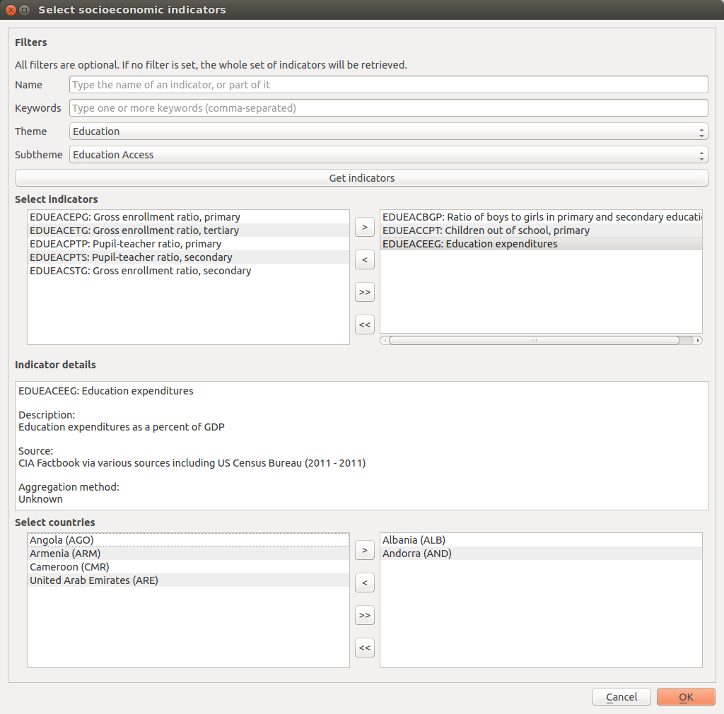
Fig. 6.1  Socio-economic indicators selection portal
The selection of data comprises an essential step for an assessment of risk from an integrated and holistic perspective using indicators. The strengths and weaknesses of composite indicators are derived to a great extent by the quality of the underlying variables. Ideally, variables should be selected based on their relevance to the phenomenon being measured, analytical soundness, accessibility, and completeness [NSST08]. Proxy measures for social and economic vulnerability have been provided by the Global Earthquake Model that have been stringently tested for representativeness, robustness, coverage and analytical soundness [KBT+14]. These are currently accessible in the OpenQuake IRMT at the national level of geography (gadm L1). Future software releases will add access to data at gadm level 2 (L2) for a selection of countries and regions. This will include the eight Andean countries of South America and countries within Sub-Saharan Africa.
Fig. 6.1. displays the Select Socioeconomic Indicators dialog that was developed to allow users to select indicators based on a number of factors and filtering mechanisms. A Filters section was developed to enable users to filter indicators by name, keywords, theme (e.g. Economy) and subtheme (e.g Resource Distribution and Poverty). The subtheme dropdown menu is automatically populated depending on the selection of a respective theme. When Get indicators is pressed, a list of filtered indicators is populated on the left side of the dialog within the Select indicators window. If no filters are set, then the whole list of indicators available within the database is retrieved and displayed within the Select indicators window.
From the Select indicators window, it is possible to select one or more indicators by single-clicking them in the Unselected list on the left. Double-clicking the selected indicator(s) moves them to the Selected list on the right, and the corresponding data will be downloaded from the OQ-Platform. Another way to move items to the right, or back to the left, is to use the four central buttons (add the selected items, remove the selected items, add all, remove all). The Indicator details section displays information about the last selected indicator: code, short name, longer description, source and aggregation method.
The Select countries dialog contains the list of enumeration types (in this case countries) that socioeconomic data is available for within the database. Countries can be selected from the list in the same manner that indicators are selected using Select indicators. Once at least one indicator and one country has been selected, the OK button will be enabled. By pressing the OK button, data will be downloaded from the OQ-Platform and compiled into a vector shapefile for display and manipulation within QGIS (another dialog will ask you where to save the shapefile that will be obtained). The layer will contain features equal to the number of selected countries and will contain all attributes selected as indicators for the given countries. Additional attributes will include fields containing country ISO codes and country names.
Note
When a socioeconomic indicator is downloaded from the OpenQuake Platform, the layer field that is created to store the indicator values will be named after the indicator code. This is because the code is shorter than 10 character, which is the maximum length for a field name according with the shapefiles specifications. The code is not so easily readable though, therefore the plugin assigns to the field also an alias, containing the full name of the socioeconomic indicator. In this way, when the layer attribute table is opened, its header will display the full name of the indicator. The code will still be visible as a tooltip, by pointing the mouse over the column header. Please note that aliases are not stored in the shapefile, but they are linked to it through the project properties. Therefore, if only the shapefile is saved and opened in a different project, those aliases will not be available anymore. In order to keep track of aliases, it is therefore necessary to save the project, including the shapefile in it.
To reduce processing time, detailed country geometries were simplified using ESRI Bend Simplify algorithm. Bend Simplify removes extraneous bends and small intrusions and extrusions within an area topology without destroying its essential shape.

Fig. 6.2 Layer attribute table
Fig. 6.2 shows the attribute table of a sample vector layer compiled and downloaded within the OpenQuake IRMT.
Note
For some countries the values of indicators might be unavailable (displayed
in the attribute table as NULL).
When the tool downloads the socioeconomic data, a project definition is automatically built taking into account how the data was organized in the socioeconomic database. At the country level data was grouped together by theme meaning that indicators belonging to the same theme will be grouped together in a hierarchical structure. This structure considers: 1) vulnerable populations; 2) economies; 3) education; 4) infrastructure; 5) health; 6) governance and institutional capacities; and 7) the environment.
Khazai B, Burton C.G., Tormene, P., Power, C., Bernasocchi, M., Daniell, J., and Wyss, B. (2014) Integrated Risk Modelling Toolkit and Database for Earthquake Risk Assessment. Proceedings of the Second European Conference on Earthquake Engineering and Seismology, European Association of Earthquake Engineering and European Seismological Commission, Istanbul, Turkey.